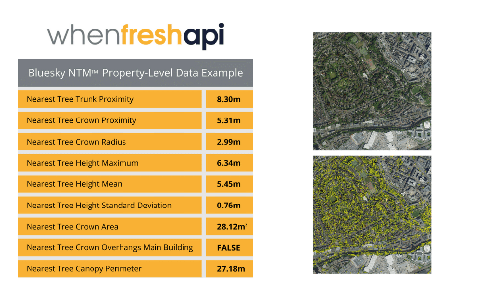
London, 6 August 2021: WhenFresh has teamed up with tree mapping specialists Bluesky to make its National Tree Map™ (NTM™) data available to insurers and other Big Data users, via the UK’s property ‘Data Supermarket’, the WhenFresh API, to address one of UK residential properties’ most significant risks.
For insurers and mortgage lenders, the proximity of trees to a property, and their size, has significant implications to the risk of subsidence. This is both in terms of draining the soil of water in hot, dry weather, and tree roots undermining the foundations of a property – particularly when considered in combination with soil type.
Yet, despite its importance, this data combination has not been readily available to the market.
Bluesky’s NTM™ is the most detailed dataset of its kind ever produced, covering the whole of England, Wales, Scotland, and the Republic of Ireland. NTM™ provides a unique, comprehensive database of location, height, and canopy/crown extents for trees 3m and above in height, which has obvious applications in property insurance, subsidence risk assessment, and mortgage lending, as well as for utilities, 5G, forestry, government, planning, and environmental management.
Rachel Tidmarsh, Bluesky International’s Managing Director, said: “Teaming up with market-leader WhenFresh enables us to provide insurers and lenders with more granular property-level data than ever before, enabling risk and pricing teams to make better decisions for new policies and the means to re-evaluate subsidence risk to existing policy portfolios and take action as needed.”
Mark Cunningham, WhenFresh CEO and co-Founder, states: “Alongside our core proprietary data, we continue to bring together ‘best-in-class’ property-related data assets as the basis for providing tailor-made solutions to empower insurers, lenders, and other Big Data users to make better, faster, and less risky decisions.
“The National Tree Map™ is a truly astonishing piece of work and we’re thrilled to welcome Bluesky to our ever-expanding family of data partners. Making the National Tree Map™ data easily accessible to our existing and potential customers via the WhenFresh API is another great step forward.”
WhenFresh is a leading supplier of property attribute, risk, peril, environmental, geospatial, valuations, market and climate data, and related solutions, primarily to UK home insurers and banks, combining hundreds of proprietary, private, and public data sources in a single place.
Try the new WhenFresh “Mini-Demo” below to see a selection of some of the residential property data items that leading Mortgage Lenders and Insurers most commonly call from the WhenFresh API to support their automated decisioning. WhenFresh are able to supply these data items and many, many more – including the National Tree Map™ data – for virtually every residential property in the UK.
[formsite host=”fs27″ key=”m_OmK8apOTDFAj315ZTI88eLrX2OJLdKFzpUCZwnDno” width=”100%”]
To find out more about the property attribute, risk, peril, topological, geospatial, environmental, climate, market and valuations data now available via the WhenFresh API – the UK’s Residential Property “Data Supermarket” – please call us on 020 7993 5818 or complete our short enquiry form.
The UK’s first ever address-level air pollution dataset was launched by the Central Office of Public Interest (COPI) on 17th March 2021, making available unique new Air Quality Reports for every address in the UK.
As widely reported by The Times, BBC and other major news outlets in recent days, these Air Quality Reports are available free to the public at www.AddressPollution.org and provide the levels of three toxic pollutants – PM2.5, PM10 and NO2 – at any given address, with a Low, Medium, Significant, High or Very High rating, based around World Health Organization (WHO) limits.
Recent studies show an estimated 99,000 early deaths every year in the UK [1] are attributable to dirty air and nearly 8m UK addresses [2] exceed the WHO limits. The new rating system is based on 1.5 billion data points generated by leading air pollution experts at Imperial College London and is accurate to 20 square metres.
Now that this data is available, COPI have launched a legal campaign to make it mandatory for the property sector – and estate agents in particular – to report air pollution data to potential home buyers. Humphrey Milles, founder of the COPI, said: “Air pollution affects everyone. It is a dangerous, invisible killer. With this national roll out, it would be shameful for the property industry to not start acting in an honest, transparent way. Lives depend on it. Everyone has a right to know what they’re breathing.” This air pollution dataset therefore has major implications for estate agents, mortgage lenders and insurers among others.
Mark Cunningham, CEO and co-founder of WhenFresh says “It has become increasingly clear that air pollution has a major impact on people’s health and, with public awareness growing and this air pollution data now being readily available, it’s easy to see how this can also impact the saleability and value of properties in high pollution areas. Much like the presence of asbestos or radon, or flood risk, if data is available that may materially impact the value and/or risks associated with a property, mortgage lenders, insurers and others interested parties will want and need to understand it. Lenders certainly take any environmental issues that might impact the value of the properties they effectively co-own very seriously.”
Example Report from COPI / AddressPollution.org
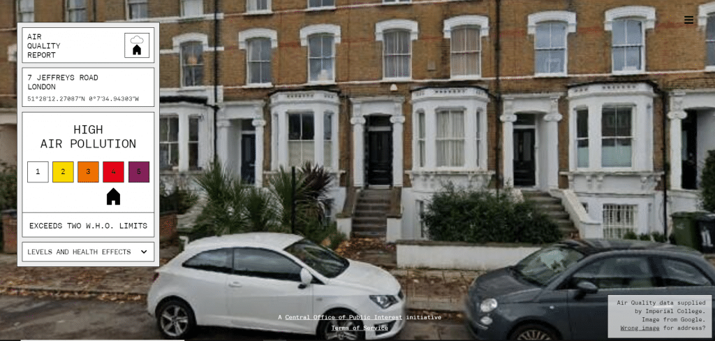
Pollutant one: PM2.5 – At this address, the annual average of PM2.5 is 12.66mcg/m3. The World Health Organization limit is 10mcg/m3. This study shows 19.9% of strokes were attributed to exposure (for a year or more) of PM2.5 concentrations exceeding 10mcg/m3. PM2.5 can also cause asthma, jeopardize lung functions and promote cancer.
Pollutant two: PM10 – The reading for PM10 at this address is 21.00mcg/m3. The W.H.O. limit is 20mcg/m3. Exposure (for a year or more) to 20mcg/m3 leads to increased risk of total, cardiovascular and diabetes mortality. Exposure to PM10 also affects lung development in children.
Pollutant three: NO2 – The reading for N02 at this address is 31.56mcg/m3. The W.H.O. limit is 40mcg/m3. However, exposure (for a year or more) to 30mcg leads to a 5.5% increased risk of disease related mortality.
To find out more about accessing the COPI Air Pollution data for commercial use via WhenFresh and/or all the property attribute, risk, peril, topological, geospatial, environmental, climate, market and valuations data now available via the UK’s “Residential Property Data Supermarket”, the WhenFresh API, please call us on 020 7993 5818 or complete our short enquiry form.
References
[1] “Global mortality from outdoor fine particle pollution generated by fossil fuel combustion: Results from GEOS-Chem”, Science Direct, April 2021, https://www.sciencedirect.com/science/article/abs/pii/S0013935121000487#abs0015
[2] “addresspollution.org data analysis”, Central Office of Public Interest, March 2021.
[formsite host=”fs27″ key=”m_OmK8apOTDFAj315ZTI84swdkdWh1NuFzpUCZwnDno” width=”100%”]
As Storm Christoph has just reminded us once again, accurate and predictive flood data has never been so important to UK Home Insurers. It is timely news therefore that WhenFresh has partnered with leading flood risk specialists Ambiental Risk Analytics (Ambiental) to make its flood data available via the UK’s property ‘Data Supermarket’, the WhenFresh API.
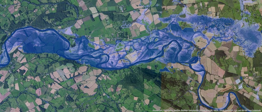
WhenFresh already supplies data to many of the UK’s leading insurers and eight of the top ten banks. Ambiental, the specialist flood and climate analysis division of Royal HaskoningDHV, has developed its UK FloodMap™ and UK FloodScore™ solutions to provide insurers with detailed, highly accurate visualisations of potential flood risks across 100% of the UK.
This includes fluvial (rivers), tidal, and pluvial (flash flooding) risks, with flood depth and velocity information down to individual building level. Ambiental’s models include 25% more rivers than any other flood data source.
Rob Carling, Ambiental’s Channel Sales Manager says: “We employ best-in-class flood modelling technology and the highest resolution data available in UK FloodMap and FloodScore, providing insurers with clear, detailed, and easy-to-understand flood information for all major floodwater sources, down to individual building level for a range of return periods. Our flood data can be readily integrated with underwriting pricing systems and we’ve made it easy to combine vulnerability data and depth-to-damage curves to understand risk and estimate loss more accurately.”
Carling continues: “Even if you’ve already got a source of flood data, our specialist flood mapping data layers can support your flood risk strategy by giving you a more accurate and complete view of flood perils. In the insurance and banking sectors, it is also used to assist in compliance, such as with Solvency II, and meeting best practice guidelines.”
Leading data supplier WhenFresh has built the WhenFresh API as the UK’s residential property ‘data supermarket’, as CEO Mark Cunningham explains: “The WhenFresh API provides insurers, lenders, and other ‘big data’ users with access to over 200 proprietary, private, and public data sources in standardised, readily-consumable formats, via a single, simple API integration.
“We’ve now assembled over 2tn data items in one place and can provide all the property attribute, topological, geospatial, environmental, risk, peril, valuations, market and climate data that insurers, lenders and other big data users need to support their underwriting, pricing, property valuations, mortgage decisioning and more. The Ambiental flood data is an excellent addition to the range of data available via the WhenFresh API and makes this easily accessible both to existing and new end users,” concludes Cunningham.
To find out more about the Ambiental Flood data and all the property attribute, risk, peril, topological, geospatial, environmental, climate, market and valuations data now available via the WhenFresh API, please click here or, to arrange an introductory call and/or demo: contact WhenFresh.